Black Canyon of the Gunnison National Park
May 21, 2021
Today we drove to Montrose, Colorado

It started lightly raining last night and we hooked up the RV in some light showers.

We took Highway 145 and rode along the Delores River.

At the top our climb the rain turned to snow at an elevation of 10,450 feet.

It was cloudy but we saw mountains as we drove past Telluride, CO.

Our site in Montrose, a wide pull thru with picnic table area.

The San Juan Mountains on the picnic side of the site.

And tree covered hills in the front.
The rain and snow were dirty so I rinsed and squeegeed the RV windows-
minimal effort for maximum views. To start the new place off right I also vacuumed the RV and we did the laundry. Tomorrow our first peek at the Black Canyon of the Gunnison.
May 22, 2021
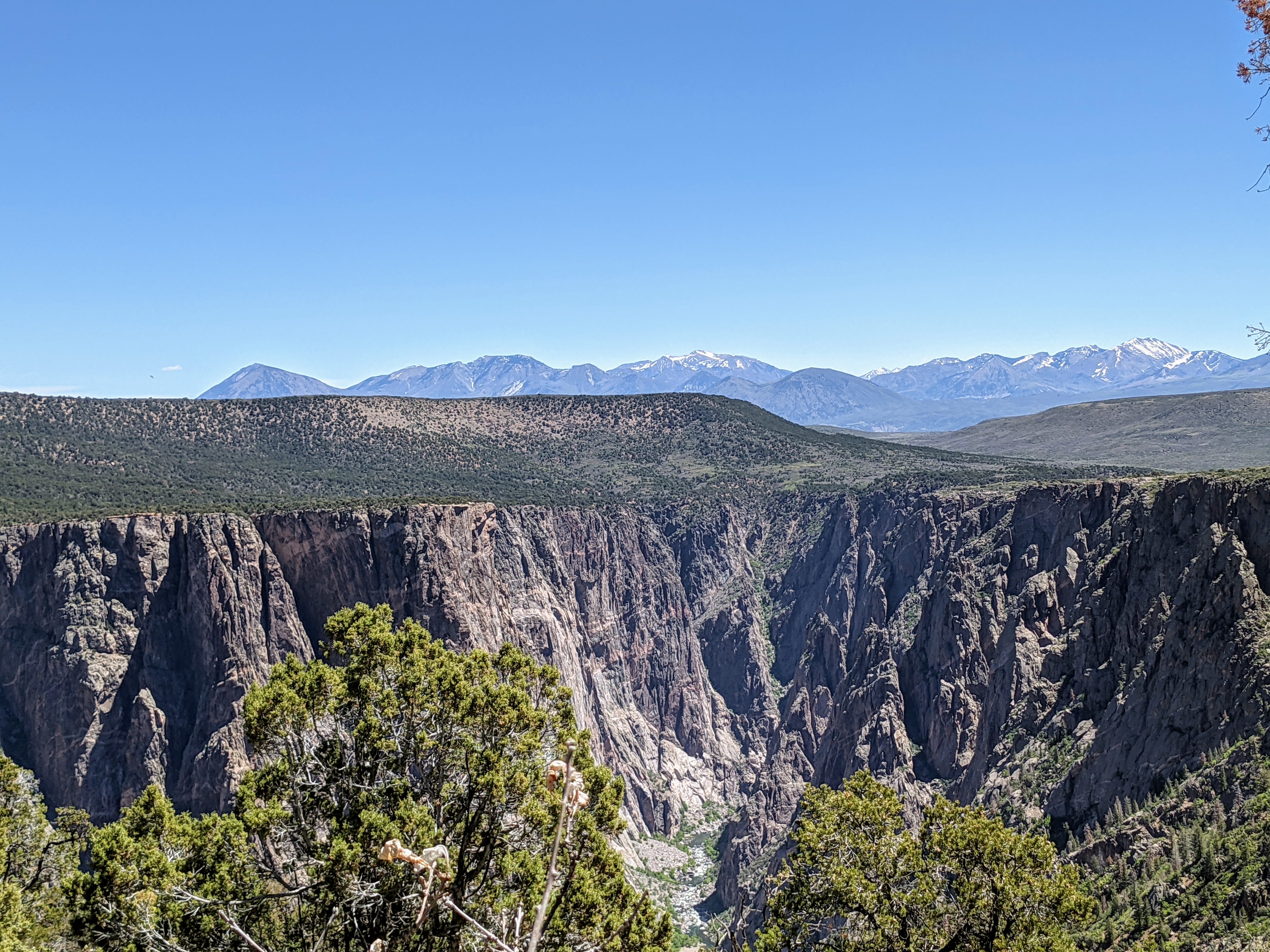
We took our first look at the Black Canyon of the Gunnison today.

Black rock with sharp fins carved by the Gunnison River

It's a tight canyon at this point and we are right on the South Rim

We hiked the Rim Rock Trail to the Upland Trail

Here is the Gunnison Point overlook, obviously built right on the rock of the canyon.

Below you can see the Gunnison River, which carved this canyon.
It has dams now that divert water to reservoirs.

Gunnison Point
"Swift water of the Gunnison River and abrasion from the sediment it carries are the chief cutting tools in the deepening of Black Canyon, but there are other forces important to the carving of the canyon. Moisture entering joints and fractures promotes weathering. As the fractures slowly widen, large rock masses are gradually weakened to the point where they shed and tumble to the canyon floor."

Gunnison River from Pulpit Rock
"What the river can't carry away accumulates as steep piles of talus against the canyon walls or creates rapids in the river."

Us and the long view from Pulpit Rock

The view from Cross Fissures
"It took about 2 million years to shape the canyon as you see it."

Getting artsy with Arrowleaf Balsamroot which is in bloom all around the overlooks.

Silvery Lupine at the Rock Point Overlook

Rock Point Overlook

The Devil's Overlook

Perhaps because it goes straight down from here they call it the Devil's Overlook.

And that made me give this circular formation the name of Devil's Cauldron.

At High Point you get a clear view of the West Elk Mountains.

Time for a talk on coyotes with Ranger Hannah.

The multi-colored fur of this coyote helps it hide here to better kill the smaller animals it consumes like rabbits and chipmunks. The coyote was hunted in the 1880's by ranchers but instead of going extinct it increased its territory from the Rocky Mountains to all over North America.
May 23, 2021
We started the day at church. St Mary's in Montrose was full, no spacing 6 feet apart and not many wearing a mask. This was a little too soon for me so I masked up. In the announcements they mentioned a mask burning on Tuesday, the congregation seems happy to be done with masks.

We drove east on Highway 50 to Curecanti National Recreation Area to hike in Black Canyon. On the way we went past the construction area (not working on a Sunday) they will be blasting the rock walls to widen the highway, it will take a year and a half to finish.

First trail is Pine Creek Trail
"Descend 232 stairs along the cascading Pine Creek, then follow the old narrow gauge railroad bed along Morrow Point Reservoir."

It was beautiful to be down along the Gunnison River. The trail was originally a railroad
"But passengers in the open-air cars also experienced sunburn, windburn, cinders and soot!
Later, motor vehicle travel replaced rail service here."

The trail is right along the river

Across the river you can clearly see where these rocks came down from.

We enjoyed the Pine Creek Trail.

The end of the trail when the river widens.

As a bonus we spot a bald eagle across the river.

What a beautiful place.

We drove 11 miles west to the Mesa Creek Trail,
this is the Cimarron River flowing into the Gunnison River here.

A gentle decline down a trail takes us to the river and a bridge across it.

The brown Cimarron River can be seen on the left bank while the clearer Gunnison River rolls along on the right side.

It is another great hike in a beautiful spot.

The end of the trail, we need to turn around and go back.

The walls are formidable.

Jim hikes over some fallen rocks in a small part of the trail.

You have to love an overhang on the trail, especially here with all the sparling rocks.

And here is Mesa Creek which has a small but fun waterfall.
Jim took a video to share with you, if you watch carefully you can see his shadow in the water.

Morrow Point Dam now regulates the down river water flow and provides electricity for the area.

"Captain John Gunnison explored this area in 1853. His goal was to locate a possible transcontinental railroad route. His party found a chasm so imposing that he gave up his plan to follow the river into this canyon. Gunnison's name endures in this county, in spite of his expedition's failure to establish a railroad route. Over 30 years later, another group successfully surveyed the depths of this "Black Canyon of the Gunnison" for construction of a railroad."

That is the end of our trail today.
"Promoters called this the "Scenic Line of the World" to entice travelers to see western Colorado by rail. The Denver & Rio Grande guidebook Around the Circle invited readers to join the trip: "Unlike many of the Colorado canyons, the scenery in this one is kaleidoscopic, ever changing. Here the train glides along the close, exalted walls." British author Rudyard Kipling found this train ride through the canyon less than sublime: "...we entered the gorge, remote from the sun, where the rocks were 2,000 feet sheer... There was a glory and a wonder and a mystery about that mad ride which I felt keenly, until I had to offer prayers for the safety of the train."

And to put a finish on the day Jim grilled up some steaks on the grills provided by the campground.
May 24, 2021
An exciting day for the truck

New tires! Well the truck is excited. We drove over 18,000 miles on the old ones (bought used) and now we can enjoy these fresh treads for the rest of the trip.

Jim & I went to the Museum of the Mountain West.
"The Museum of the Mountain West is a history museum off U.S. Route 50 in Montrose, Colorado. It includes a collection of historic log cabins, Western town stores, and other historic buildings which have been moved to the site. The museum was listed on the Colorado state register of historic properties in 2018."

The museum is set up with realistic settings for the over 500,000 items that were collected by Richard E Fike from the time he was four until today.

Recreated stores hold items that would have been there and you walk through the shops and offices.

The clothing store had this lovely dress and the bear coat hanging behind it.

Hat boxes lined the shelves

as did boxes of underwear, now there is reality.

A dental office from the forties - not much different than today.

John, our personal tour guide, told us stories about individual items throughout the museum. Here he is showing Jim the Carriage Works which had blacksmithing tools and several carriages.

The Clipper Saloon had a great bar and table for poker.

You can ring the bell in the old schoolhouse.

And when was the last time you saw a dictionary this big.

We toured inside this "Montgomery Ward" house with 10 foot ceilings.

The museum became a non-profit in 2005 and people are donating items as large as log cabins and churches.

This was moved whole from another location in town. A local resident who attended the church as a child did not want it to be destroyed so he donated $18,000 for it to be moved to the museum. Now people are getting married here.
This is a funky museum and a fun place to visit.
May 25, 2021

We started the day off with a hike at Warner Point, off to the side we had a clear view of the San Juan Mountains.

And the ranch land below. I imagine this land has been in the same family for generations; who could give up the views and fertile land.

A lightning strike in 1996 ignited a blaze below that torched some 800 acres.

A fellow hiker from Florida was taking numerous shots of this lizard basking in the sun. The lizard was an electric blue color which the hiker said he had never seen back in Florida.

The twisted nature of this juniper is an adaption aide to survival.
"The sap in straight-grained trees rises directly from bottom to top, providing nutrition to branches on only one side. The spiral grain sends sap around the trunk with the chance that all of the branches may benefit."

This pinyon tree shows animal damage.
"You can see the scars where a rodent gnawed into the inner layer in winter. Chomping down to the cambium layer gives porcupines a high-energy source at a time of year when few other foods are available."
A view of the Black Canyon and the Elk West Mountains.

500-850 year old Pinon Tree
"The groves along the ridge and some on the north rim are approaching 850 years old. Individual specimens elsewhere in the southwest are older, but this primeval woodland as a whole, a forest community, is rare."
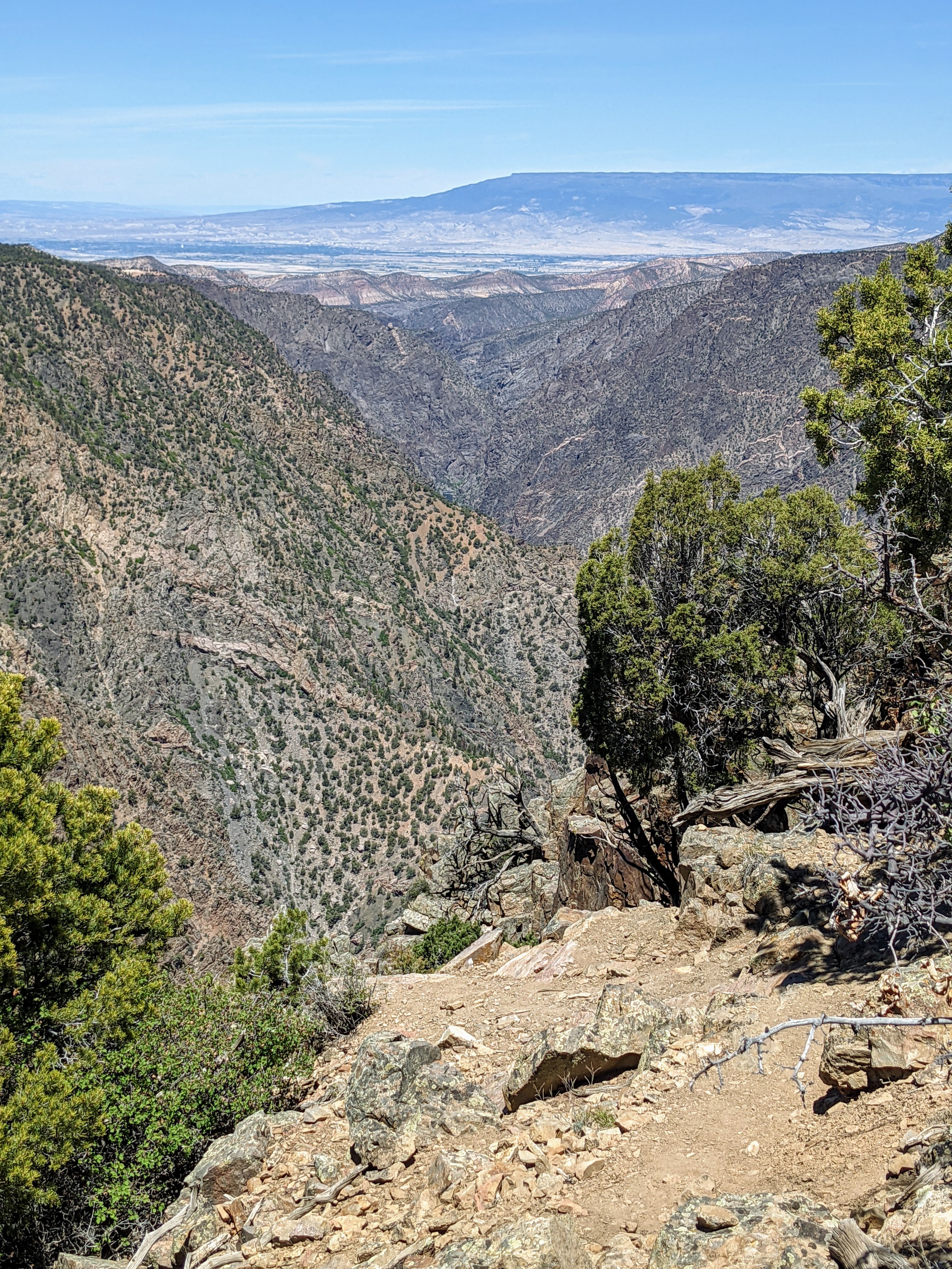
Here at Warner Point the Canyon opens up wider.

The Gunnison River still cutting through at the bottom.

We spot another lizard out to soak up some sun. This guy was yellow and green.

Birds soar by while flying around the canyon.

How the pine trees manage to grow on the rocky slopes is amazing.

We give two thumbs up for Warner Point.

Trying to get artsy again with a photo.

Unconformity. A gap in time.
"Each layer of rock marks a span of geologic time. But often the layers representing certain spans of time are absent. Either nothing was being deposited at a given time or deposits were later eroded away and left no record of their presence. As a result, young rock may rest directly on very ancient rock. This area of contact between younger rocks and older rocks marks a gap in the geologic record. This area of contact is called an unconformity.
The thin, light tan layer you see on the canyon rim is Entrada Sandstone, a mere 165 to 170 million years old. The rock immediately below it was formed in the Precambrian period and is about 134 billion years old, the oldest rocks in the canyon. More than a billion years is absent from the geologic record of Black Canyon!"

Sunset Point, we were here for lunch, still gorgeous.

See the Gunnison River at work.


Next stop on the scenic drive, Dragon Point. Not sure how it got its name, perhaps the river looked like a dragon tail?
Here is a short video from Dragon Point

The grey cliffs are still striking, especially up close.

It is a long way down from the overlook.

These flowers are the first to greet us a Cedar Point.

Jim enjoys the view of the river and canyon.

Here you can see how fast and deep the river is flowing.

The canyon walls are getting closer together.
"The Gunnison River has a very steep gradient. Within the monument, the river has an average fall of 95 feet per mile. This gives the river the energy needed to cut downward faster than other kinds of erosion can widen it."

This wall is named the Painted Wall.
"These bands of lighter colored igneous rock called pegmatite dikes are more resistant to erosion than the dark gneisess into which they intrude."

I like the wavy nature of the pegmatite dikes.
"The patterns that inspired the name Painted Wall were created more than a billion years ago when molten rock was squeezed (intruded) into fractures and joints in the existing rock, then cooled and hardened. Unlike a painting, these patterns are 3-dimensional. If you were to slice off a section of cliff, an entirely different pattern would be revealed."

"At 2,300 feet, Painted Wall is the highest cliff in Colorado. If the Empire State Building stood on the canyon floor, it would reach slightly more than halfway to the top of the cliff."

Chasm View
"The Narrows, between Pulpit Rock and Chasm View, is the shallowest and narrowest section in the monument. Here the canyon is less than a quarter-mile across."

"The words of an early surveyor reveal another view of this erosion:
"Hereto was unfolded view after view of the most wonderful, the most thrilling of rock exposures, one vanishing from view only to be replaced by another still more imposing. A view which could easily be made into a Scottish Feudal Castle would be followed by another suggesting the wildest parts of imposing height and majestic proportions..."

"In 1900, William Torrence led a crew to explore the possibility of diverting Gunnison River water for farming. His first trip ended with the loss of most supplies and a difficult climb to the rim.
Torrence set out the next year with A. Lincoln Fellows, with a rubber air mattress. The trip lasted nine days and was not without trouble. "At the 'Narrows' the fun began. The Canyon is full of great boulders, which form bridges across the stream. Over these we must scramble, one getting on top and pulling the other up. We spent a day going a quarter of a mile. The walls are almost perpendicular in many places and some 2,000 feet or more to the top."

A ranger at Chasm View told us that kayakers on the Gunnison have to be the best in the world. The falls and rapids below are Class 5.

While I mistakenly thought the river was going over some rocks, there are 20-30 foot waterfalls below. Kayakers have a 1.5 mile portage around the falls area below here. Currently the water was not high enough to kayak so no spotting any on our trip.

Indian Paintbrush

Supermoon tonight. Clouds covered the skies so no view of the lunar eclipse.

And sunset puts some color in the night sky.
May 26, 2021
Rest day, no touring on this cloudy day.
Okay 1:15pm let's go to town and see some historic buildings.
"Early-day Montrose was a typical western town characterized by wooden sidewalks, hitching racks, and when it rained, deep-rutted, muddy streets. Despite the lack of conveniences and the typical "rough and rowdy" element attracted to frontier towns, Montrose began to emerge as a major trade, service, and distribution center for southwestern Colorado. Permanent buildings were eventually constructed that housed banks, general stores, a newspaper, and livery stables."

The quirkiest building on the Historic Downtown Walking Tour goes to Fox Theater.
Completed October 31, 1929, just two days after the Stock Market crashed. Designed in Moorish Exotic Revival style, the building sought to convey fantasy, as with much 1920s architecture. Throughout the Depression, the theater was a common gathering place with wild gimmicks like pajama contests, pillow fights, vaudeville acts and "Bank Nights" to help Montroseans escape daily life.

This ornate upstairs was the Thomas Hotel 1906

Frees Building 1905
The main level housed a grocery and a bakery and a rooming house occupied the upper level.

Independent Order of Odd Fellows Hall
Lodge #65 was first organized in 1885 and built here on Main Street in 1905.
It is still owned by the Odd Fellows, making it the longest single-owner held building in Montrose.

Townsend Building 1896
Built in 1896 by TB Townsend to replace his 1883 store to house a Hardware and Furniture store on the main level. The second story housed a Green Stamp Redemption Center for many years.
"While visiting Downtown Montrose, take time to enjoy the many sculptures that are displayed. Each year the PAX works to bring quality works of art, on loan, to display in public locations around Montrose. Their goal is to enhance the community by creating new opportunities for people to come together as a community and enjoy direct engagement with quality works of art."

"WHERE EAGLES DARE" BY VIC PAYNE
ON LOAN FROM THE PRIVATE COLLECTION OF WILLIAM F WIDGER

"BAD DECISION" BY VIC PAYNE
ON LOAN FROM
THE PRIVATE COLLECTION OF WILLIAM F. WIDGER

I love the detail in this sculpture, the bottom of the cowboys boot has a wear mark in it.
Both sculptures are quite eye catching. Who do I talk to in Arlington Heights to bring PAX - Public Art eXperience to my hometown?
May 27, 2021
Today we drove to the North Rim of the Black Canyon.

We hiked to Exclamation Point

You can see the Gunnison River in a long straight shot.

We enjoyed the North Rim as it was very natural, almost no barriers between you and the canyon.

Here is the edge, nothing between you and the edge.

A look at the Painted Wall from the North Rim

We also hiked the Chasm View Nature Trail.

"From rim to rim it's 1100 feet
From rim to river it's 1723 feet
Age of the rock is 1.7 billion years.
It's hard to imagine the age of rock that is 1.7 billion years old. With an average life expectancy of 77 years, in the U.S., our lives comprise less than one millionth of that age."

"Across the canyon you can see streaks descending on the cliff. It's called desert varnish - a mixture of iron and manganese oxides concentrated there by bacteria with the help of a recurring supply of water."

We spotted some climbing gear at Chasm View, then when at the Narrows, thru binoculars we were able to see the climber ascending the cliff wall. He was nice enough to wear a red top which made it easy to keep track of him.
"It isn't unusual to see climbers scaling the cliffs in this part of the canyon. Such recreation taxes all of the abilities one can gather. Some cling to the walls for an afternoon, some for a few days. Regardless of the excursion, many observers question the sanity of climbers.
Some of the scalers might say they are looking to test their physical endurance. Some for the thrill or excitement of hanging on the walls, or perhaps something spiritual."

The fins are so jagged, they look painful.

Through the binoculars we could see the falls in the Gunnison river,
we tried to take a photo with the binocular but it's not as impressive as we wanted.

Balanced Rock viewpoint.

Big Island viewpoint had these fins.

All the views are great.

At the last viewpoint I spied this blooming cactus on the rocks.

The rocks here at Kneeling Camel are angular, a first around here.

The boxy stones made the walls look like buildings.

The road out of the North Rim has great views of the West Elk Mountains.
If you go to the Black Canyon of the Gunnison, go to the North Rim.
May 27, 2021
Today's hike is the Oak Flat Loop Trail

It had oaks on it, it was a loop, it was not flat.

Just a step onto the trail and Jim spotted a deer munching on some leaves.

The views were great

The Gamble Oak in the foreground was starting to leaf out

Some of the canyon rocks popped up on the trail route.

The Gunnsion River

We started at the top and climbed down a littler further than this wall here, time to climb back up.

Canyon views, and some shade on a hot day made for a great trail.

Oregon Grape is also blooming now.

The sun played with the canyon at Gunnison Point Overlook illuminating the back only.

And finally we went to a Ranger talk on geology where making brownies was used as the simile for the making of the canyon. I can make brownies, only God can make the beauty of this canyon.
May 29, 2021
Today we went to Barrels for Bucks at the Montrose Event Center.

Montrose Event Center was a great indoor space.

We saw warm-ups where they walk or trot the horse around the barrels.

First up to compete, the Pee Wees.

Then the adult riders, we saw 50 Barrel racers.
Here's a video so you can see a barrel racer in action.
Well that wraps up our time here in Montrose, Colorado.
It has been a great time.
Comments
Post a Comment