Badlands National Park
July 22, 2021

Happy Birthday Jim! A short 116 mile drive takes us to the Badlands today.
Besides a short drive we had a grocery stop at Wal-Mart where we picked up some birthday apple fritters.

We passed the Crazy Horse Monument a carving 70 years in the making and still going.
"The Crazy Horse Memorial is a mountain monument under construction on privately held land in the Black Hills, in Custer County, South Dakota, United States. It will depict the Oglala Lakota warrior, Crazy Horse, riding a horse and pointing to his tribal land."

We have a lovely view of the Badlands from the campground.

There is a trail leading out that I will have to check out later.

It is not all dry, there is a small pond that some rancher is using for irrigation.

We have a long campsite with a tree that provides some shade for our refrigerator, which is great since it is currently 100 degrees out and sunny.

When we checked in we were warned that winds blow here a lot at any time.
Apparently the owners of this tent apparently did not stake it down, perhaps they did not get the same heads up we did.

We stopped by the Visitor Center to get the lay of the land.

The views just outside the Visitor Center are already inspiring.

“I was totally unprepared for that revelation called the Dakota Bad Lands…what I saw gave me an indescribable sense of mysterious elsewhere—a distant architecture, ethereal…an endless supernatural world more spiritual of the earth but created out of it.” Frank Lloyd Wright 1935

At 8:00 pm the clouds in the distance and lightning.

By 8:15 pm the winds had spun this pop-up and the campground manager told them they should shut the pop-up down so we went outside to help them. After we got this one down we went to help another family in a pop-up take theirs down too. We chatted until 9:00 pm when the rains chased everyone inside. These 2 families sat out the rain in their cars. By 9:30 they started to reset up their campers.
July 23, 2021
Today we set off for the Notch Trail.

Well that sign is clear. We did not see any rattlesnakes today it is most likely too hot for them.

The challenge here is to ascend on this ladder.

Victory over fear of falling, it was actually a nice way up.
Going down was awkward at the top the rungs felt very far apart when you can't see them, but I successfully got down the ladder as well. phew

The badlands are amazing.

The view from the notch.

Blue skies at the moment.

View of the White River Valley from the notch.

A backcountry camper's campsite, definitely needed to bring their own water to that site.

Jim on the Notch Trail.

So many side trails call me, the Badlands allow you to hike anywhere.

We drove a little down the road to the Big Badlands Overlook.

Happy even if it is really hot and humid here in July.

"Fancy yourself on the hottest day in summer in the hottest spot of such a place without water-without an animal and scarce an insect astir-without a single flower to speak pleasant things to you and you will have some idea of the utter loneliness of the Bad Lands." Paleontologist Thaddeus Culbertson

Just glad I am not in a Contestoga wagon crossing these.

Prairie Sod Home
"Edgar I. Brown, born in 1854, came here with wife, Alice, and son, Charles, to homestead in the BADLANDS when he was 55. Their first and only home was a side hill, sod wall, dirt roofed house. About it they built up a humble homestead. "

". . .it is a classic example of the frugal but satisfactory life of the men who built the West."
Behind the paper wall is the bedroom.

The top half of the wall shows the sod bricks while the lower half are faced with wood boards.

A frame house built added on to the sod house with wood floors and wallpaper, quite the upgrade.
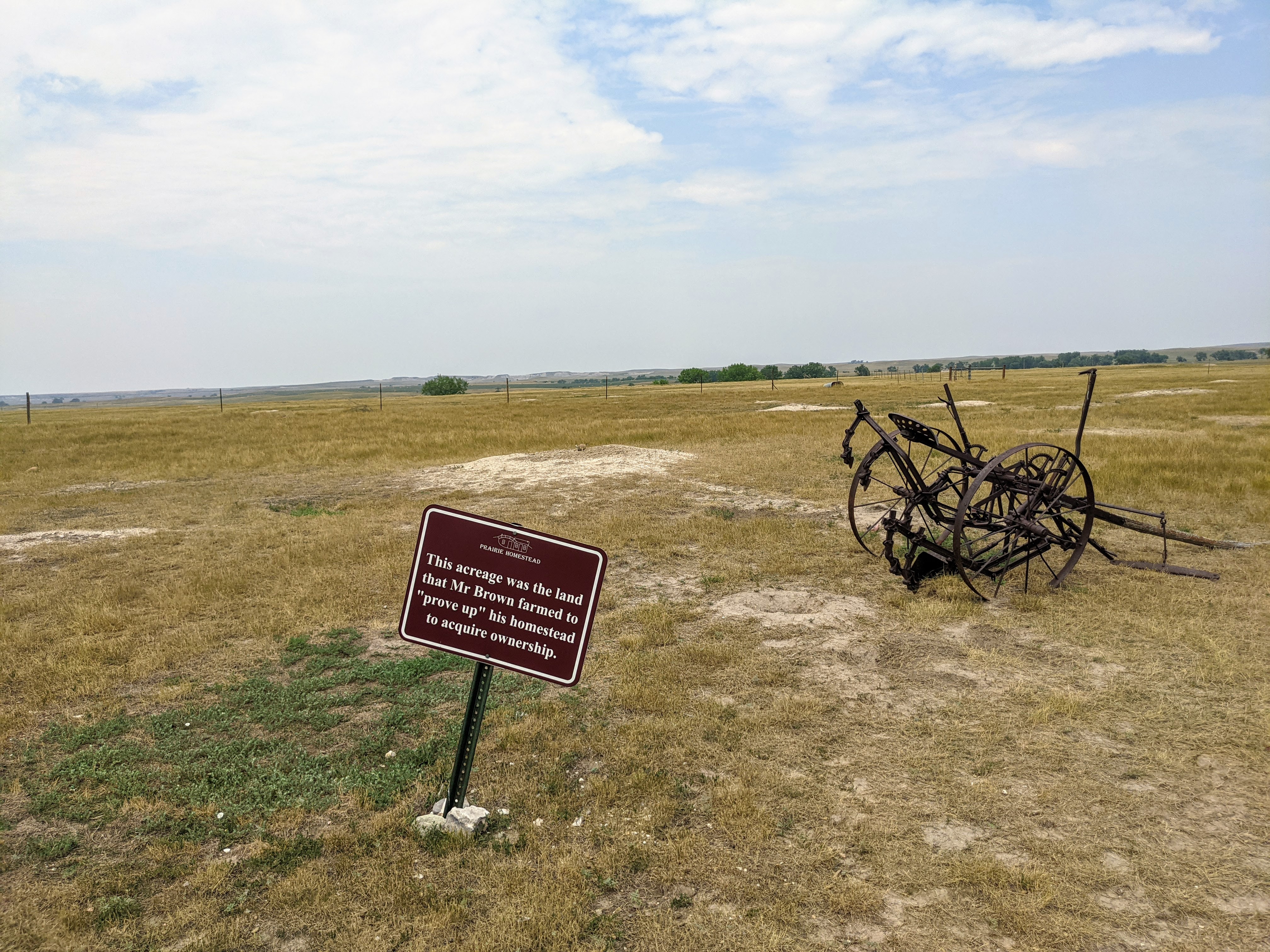
"Homestead Act - May 20, 1862 - A person who had reached the age of 21 could file on 160 acres of land for $18.00. The homesteader had to build a house, plow a small acreage for crops and establish a residence for 5 years in order to receive ownership or "prove up"."
85%-90% of the claims were abandoned, it is a hard life here in the Badlands.

Could you have lasted 5 years here?
From left to right, the sod house, addition of frame living room, sod mound house-the underground food storage, and of course the outhouse. It does not feel like a life I would have liked.
July 24, 2021

Oh it is hot, and it is going to get hotter.

So we headed out early to hike the Medicine Root Trail.

The sunflowers were appreciating all the sunshine.

The Badlands felt white hot under the clear skies today.

Saddle Pass was refreshing, as a breeze washed over us here.

This trail had plenty of prairie grass among all the limestone rock formations.

We kept cool with our neck coolers today and drank plenty of water.

Another wildflower, hoary vervain, their bright purple really pops here.

After the hike we went to the Fossil Lab in the Visitor Center, partly because it was air conditioned.

There were 3 women working on uncovering fossils.

They looked into a microscope to work with their mini jack hammers and you can see what they see on this monitor. Pretty cool. It appeared to be painstakingly slow work, but Grace who was working on it said it was exciting to uncover the skull.

To cool off this afternoon we took a dip in the campground pool, yes those are the Badlands in the background. We met plenty of other campers in the pool.

Since we have a little shade it was comfortable enough to do some reading at the campsite while enjoying the view.

We also attend a night sky ranger program this evening.
There were 5 rangers there, 3 of them very familiar with the night sky.
Here on the left is Jupiter, then the Moon and upper right is Saturn.
July 25, 2021
Sunday morning went to church in Wall, SD

And since we were in Wall we had to stop by Wall Drug Store especially after seeing 33 signs for it.
"One of the world’s most well-known tourist attractions, it’s hard to believe Wall Drug Store got its start with something many wouldn’t even turn their heads at today … the promise of free ice water. But in fact, the Husteads turned free ice water into a million-dollar idea with a little determination, quick thinking and a lot of signs."

It seems more like a shopping mall these days, but you can still take your picture with Annie Oakley.
We drove back on the Buffalo Road Loop without stopping at the overlooks as we will spend another day doing that, a little earlier in the day to avoid the high heat. It was a great ride.

We read & swam in the pool during the heat of the day and came out at 7:00 pm to hike a couple of trails. We spot 2 deer along the road.

"Over time, water sliced through the earth around you, exposing sedimentary rock layers. These layers continue to erode today into dramatic canyons and spires. "

"When the Lakota looked on the land around you, they saw the Paha ska (white hills)-a place of bountiful hunting."

It was breezy and comfortable to hike as the sun set.

"French trappers in the mid-1700s, frustrated by the land's sharp peaks and crumbling rock, regarded the area as les mauvaises terres (bad lands). The Lakota also began calling this place Mako sica (land bad)."

We hiked to this sign, I don't get it, there should be no end to the trail.

Sun setting, a perk to hiking in the evening.
In between the two trailheads was this picnic table shelter that was taken over by Cliff Swallows.
Have a look and listen.

Next we hit the short window trail.

The trail leads to an opening that looks out at the Badlands.

This rising pink cloud accented the white rocks nicely.

The window trail was nice, but I preferred the Door Trail.

The third trail for the night is the Cliff Shelf Trail.
"Humans have used the Cliff Shelf for more than 11,000 years. More than 50 plant species and 100 bird species have been identified in this small area."

"Water is scarce in the Badlands, which get less than 16 inches of precipitation per year. The bowl-like Cliff Shelf where you stand provides more moisture than commonly found in this desolate land.
Drawn to this spot for more than 11,000 years, humans have used the area for everything from ancient hunting camps to modern lodges."

No hunting in a National Park, so this deer here is safe from humans.

It's been another great day.
July 26, 2021
Today we woke up early before the heat of the day and set off for the Badland Loop Road to explore all of its pull-offs and overlooks.

Sage Creek Basin Overlook

Here at Sage Creek there are more rolling hills and trees.

Badlands Wilderness Overlook

Hay Butte Overlook
"Erosion left a few high islands topped with virgin sod, the slopes so steep that homesteaders could not get their stock up to graze. Instead, the homesteaders waited until the grass was ready to cut.
Then several got together, took apart a mower, and reassembled it on the top of the table. Once the grass was cut and baled, homesteaders hitched it to a cable stretched from the rim to the lower prairie - and whoosh, the bales slid down. Hence the name Hay Butte for the long table on the horizon."

It is easy to see why this area would be hard for cattle to navigate.

Pinnacles Overlook is vast, endless Badlands.

The horizontal stripes are from the different time periods that these were created.

"A thousand years ago, a hunter stood where you stand. He watched bison drift like a dark cloud shadow across prairie below. Could the herd be stampeded onto the high prairie behind the cliff on your left, and driven over the edge? If so, injured animals could be butchered on the spot, on the very edge of the camp." Known as a Buffalo Jump

The Big Pig Dig.
"Thirty-three million years ago, this area was an oasis during a drought. It attracted animals looking for water, food, and shelter. Some animals became
stuck in the mud and died. Their carcasses were trampled, crushed, and buried. This cycle repeated until the watering hole dried out. After millions of years, erosion and the work of paleontologists exposed these buried remains."

Discovery of an Ancient Watering Hole
"In the past, as today, water was a precious resource for all living creatures. Drought was frequent, but rain pooled in depressions, creating this watering hole. The water attracted many animals. Archaeotherium, an ancient pig-like mammal, came from long distances to drink and scavenge on carcasses."

Yellow Mounds
"A jungle grew here. Before that, a shallow sea covered the land. Both are gone now, but both left evidence of their passing. The sea's signature is ammonites, baculites, and clams, pearly fossils entombed in a fossil mud called the Piene Shale. This shale is exposed in the gully below you."

A jungle sprang up after the sea drained away about 65 million years ago. For a long time tree roots broke up the shale, and chemicals from decaying plants produced a yellow soil.
Yes, that is me on the Yellow Mound, I loved the colors.

"About 37 million years ago sediment from the west washed over the jungle. The jungle rebounded, covering the new sediment into a red soil. Buried by later sediments, both yellow and red soils were fossilized. We call them the Yellow Mounds Feleoso and the Interior Paleosol."

There is clearly a dry river bed down there.

Big horn sheep near Burns Basin a homesteader who raised sheep.
Here is a video of one grazing.

And four more just chilling.

Homestead Overlook
"Homesteaders poured into the Badlands when the Milwaukee Railroad completed track through the White River Valley in 1907. "Visualize if you can, one observer wrote, "a tar paper shack, tent, or dugout on every quarter section of land...and you will have a minds' eye picture of what the community looked like..." A checker-board pattern was created, bearing little relationship to the natural lay of the land. And bearing little relationship to the productivity of the land. Most of the homesteads turned out to be "Starvation Claims" and were abandoned or sold."

Burns Basin Overlook

Few people seem to stop at the prairie overlook, it is quite nice and peaceful.
Have a look at native prairie.
"The prairie around you was once part of a vast ocean of grass covering more than half the continent. Today, less than two percent of North America's native prairie remains."

Up close artsy picture of the prairie.

Panorama Point
Everyone stops at this eyepopping viewpoint.

"Rock layers in Badlands National Park contain fossils that show a
dramatic cooling and drying of global climate over millions of years. The oldest rock layers contain marine fossils, roughly 70 million years old, from when this area was underwater. Although dinosaurs lived during this time, they did not live in this area. Younger layers show evidence of cooler and drier climates. The most recent layers reveal animals and plants from an open shrubland. Today, rock layers are stripped away by erosion, exposing new fossils within these bands of time."

Fossil Exhibit Trail
A nice walk in the Badlands with signage on fossil that have been found here.

Alligator fossil at home here in the formerly water covered land
"The Western Interior Seaway once split North America in half. In some places, this vast inland sea was 2,500 feet deep and 600 miles wide."

An amazing road through the Badlands today, so blessed to see it all.
July 27, 2021

Badlands National Park
Tuesday
Clear with periodic clouds

That could explain Jim's lack of enthusiasm for grilling outside, it was so windy it was hard to keep the heat up on the propane grill.
July 28, 2021
Today we went to the Minutemen Missile Visitor Center.

This National Historic Site is divided into 3 locations, the visitor center, the command center (need to book a tour 90 days in advance and we did not have the foresight), and the missile silo.

The Visitor Center had an informative movie and these Russian missile key artifacts, as well as information on the Cold War complete with a replica bomb shelter and Duck & Cover movie.
"Although the Cold War ended symbolically with the collapse of the Soviet Union and diplomatically with START II, the potential threat posed by nuclear weapons persists. Since the 1970s, Israel, India, Pakistan, and North Korea have become nuclear powers.
As of 2015, nine countries possessed about 15,700 nuclear weapons."

A mannequin in a silo elevator.
"There is no other job that I can think of that you give a person twenty years old classified material and put them in charge of a nuclear weapon unsupervised.... You're trusting them to work on a weapons system that is part of our national defense, a national resource. They do it day in and day out."
Alonzo Hall, 44th Missile Maintenance Squadron, 1975 to 1994

The Command Center.
"The 44th Strategic Missile Wing maintained nuclear weapon systems from 1962 to 1993. Its three strategic missile squadrons, the 66th, 67th, and 68th, were each made up of five flights. Each flight controlled 10 Minuteman II missiles."
We did not get tickets to visit this site (picture from their website)

Delta-09 Missile Silo area is located in ranch territory along highway 90.
"You are standing approximately 5,100 miles from Moscow, 1,400 miles from Washington, D.C., and nearly four miles from a facility that could launch nuclear weapons.
The Great Plains once housed 1,000 intercontinental ballistic missiles (ICBMs), targeted primarily at Russia, formerly the Soviet Union. They still harbor launch facilities for hundreds of missiles"

The glass enclosed silo, half open to view the missile.
"The Front Lines of the Cold War Minuteman-land is eerie. On the surface, no weapon is visible. But beneath the empty prairies and forested hills the gyroscopes are eternally spinning... each ready to steer holocaustic destruction to a pre-selected target." John Hubbell, 1962

"From 1963 until the early 1990s, the missile silo at Delta-09 contained a fully operational Minuteman Missile, bearing a 1.2 megaton nuclear warhead. The Delta-09 missile silo was one of 150 spread across western South Dakota. In total there were 1,000 Minuteman missiles deployed from the 1960's into the early 1990's."

On the right side you can see the elevator for humans to do down into the silo.
"The yield of the Hiroshima bomb was about 15 kilotons. The Minuteman II missile's warhead packed a 1.2 megaton yield. The comparable Soviet missile delivered 10 megatons."

Here are the tracks in the back to retract the lid off the silo. In the case of an actual launch the blast-proof cover would be ejected out into the field.

While we were there a ranger went down into the mechanic's room, he was exterminating some mice.

Here is the personnel hatch. First you opened the small hatch and entered a combination to open the larger hatch to enter.
"Most maintenance work at a silo required access to underground facilities. To do this the maintenance crew had to pass through security and barriers in a process that often took up to an hour. The crews could then climb down to the equipment room surrounding the launch tube, lower their equipment, and begin their maintenance tasks. Because of the drive time to and from base, a maintenance team may only have five hours to work in the field."

The white pole is an improved perimeter security system monitored by the command center.
"During the Cold War, anyone or anything that crossed this fence was in serious trouble. Standing orders meant the use of deadly force was authorized. Motion sensors reported activity day and night."
We returned on the Badland Loop Road getting our final look

I recommend a visit if you have not been, it is truly unique.

Back at our campsite, I appreciate our little tree that provided us some rare shade out here on the prairie.
impressed you made the most of your visit with those temps, and glad you weren't in a tent!
ReplyDeleteme too
ReplyDelete