Redwoods National Park
April 9, 2021
It's time for some really tall trees.

"The Newton B. Drury Scenic Parkway-a ten-mile scenic ride winding through one of the largest remaining old-growth coast redwood forests in the world."
We stopped by the visitor center and decided to hike a combination of 3 trails to make a loop trail.

First we start on Prairie Creek Trail
"Coast redwoods are not only the tallest trees on Earth, but among the oldest. "

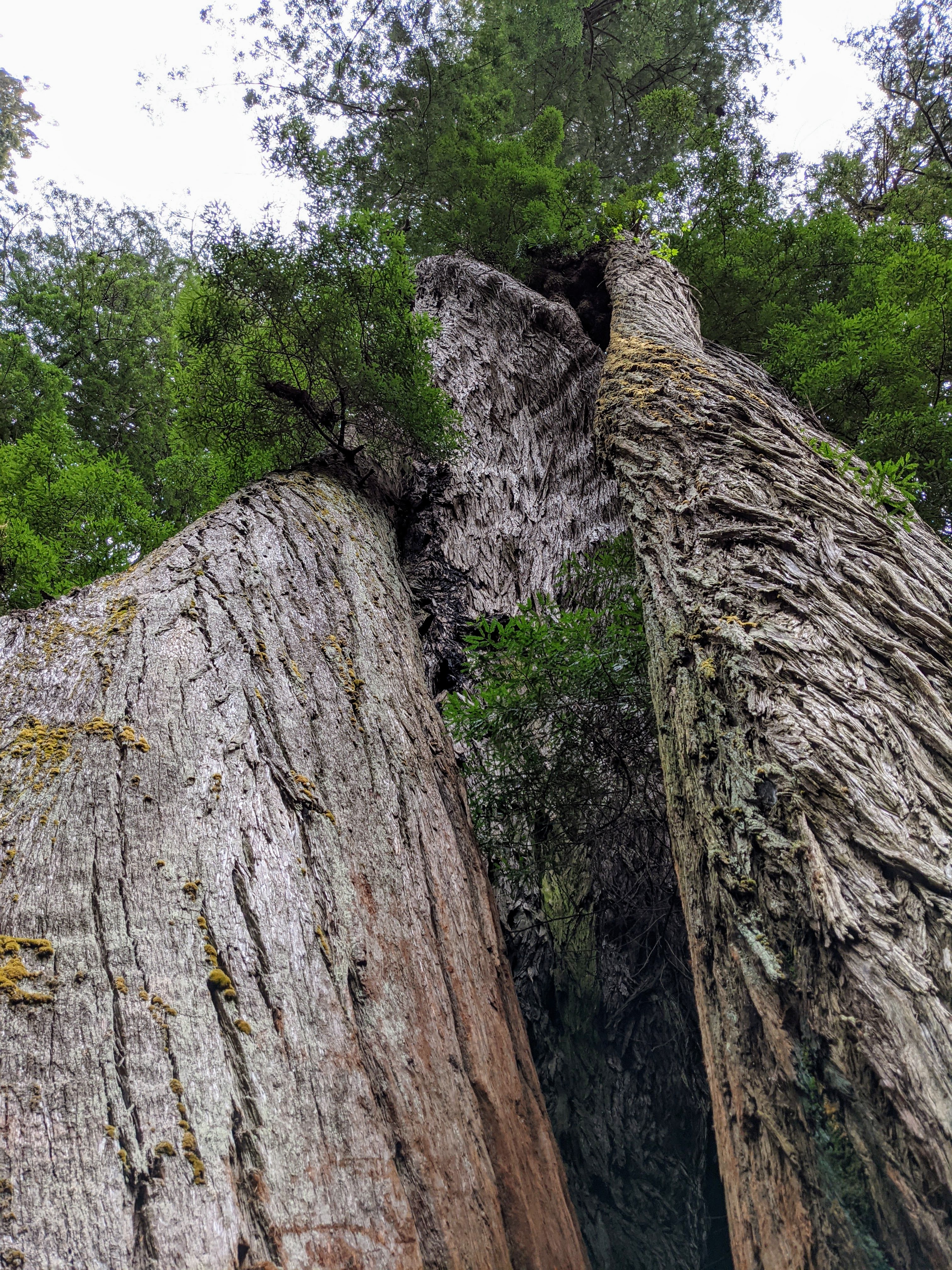
Jim sets off on trail, these trees can make him look small.
"Much of the canopy stands at over 300 feet, shadowing Douglas-fir"

"The shade produces a rich, layered rainforest to explore through a network of trails that leads over ridges, beside creeks, down fern-filled ravines, and along windswept bluffs to the beach."

These trees are very big.
"Conservationists helped preserve the groves in the Prairie Creek basin beginning in 1923."

And we are very happy that these trees were saved.

Tree growth from a root sprout.
"The Coast Redwood is the only, conifer which grows both from seed and from stump or root sprouts."

Ferns cover the forest floor here.

New growth on a fire damaged tree.
"Damage by fire, by falling, or by logging often seems to trigger this growth. Sprouts grow rapidly, being supported by the large parent root system."

A creek supplying water for these giants.

Jim easily fits in this fire damaged trunk.

We turned on to the Big Tree Trail and spotted this good sized tree that grew out of a fallen redwood.
The roots covering the fallen tree are amazing.

And here is the named Big Tree trunk, it is 286 ft tall and about 1,500 years old.

Pretty good looking for her age.
"Redwoods, like humans, grow more complex and interesting as they age. Big Tree's height and girth, and its maze of broken and regrown appendages, seem to suggest it may be one of the oldest trees in the forest."

And this good humored sign lets you know there are plenty of BIG TREES here.
Here are some features in the Big Tree.

"Damaged by fire or wind, a new trunk sprouted from dormant buds (burls) high in Big Tree's crown. This reiterated trunk alone is larger than many individual trees on the forest floor around you."

"Fire Scars The black char on the outer bark of Big Tree is an indicator that fire is a visitor to the redwood forest. Thick, insulating bark helps redwoods survive multiple fires throughout their lifetime."
As for fire damage around here this is pretty minimal.

"Epiphytes are plants that grow on other plants. Soil and water collects in large cavities and broad branches of mature redwoods. Where Big Tree's top snapped off years ago, huckleberries and ferns now grow 200 feet (60 m) above the forest floor."

Here three new redwoods grow out of this fallen redwood.

And this craziness, a tree without roots attached to the burl of a redwood. It's a great reiterated trunk example.

These ferns are covering a fallen redwood. At first I thought they were on a hillside and then I noticed the tree.
And our second trail was the Trillium Falls Trail.

There's a lush mixture of plants along the trail.

Before we reached the falls I snapped a shot of these cray burled roots.

"Along the creek, scattered patches of silky white trillium bloom in the spring."

"Trillium Falls, a 10-foot cascade flowing over rocks covered in deep-green moss."

So nice, I thought I would show it to you twice.

And then we stopped by the Corkscrew Tree.
It really twisted around in a very impressive way.
And finally, we went on the Ah-Pah Trail.

More verdant woods.

And very tall redwoods.

More gnarled burls at this trees base.
It was another good day.
April 10, 2021
Today we are ready to go on the Coastal Drive Loop, here is how its described
"This narrow road with steep grades and sharp curves offers wide panoramic views of the Pacific Ocean and Klamath River estuary. Whales, sea lions, and pelicans may be seen from overlooks high above the crashing surf. Enjoy a picnic with breathtaking views at the High Bluff Overlook, and don't miss the World War II radar station-disguised in the 1940s to look like a humble farmhouse and barn."

Okay this is a pretty great wide panoramic view of the Pacific Ocean.

It was a beautiful day with temperatures in the 50's

"Evidence of dramatic earth movement is visible all around you: split rocks, steep cliffs, and even cracks in the asphalt. The rocks are ocean floor sediments deposited over 150 million years ago, which have been shoved up along the coastline. Off the coast looms the Cascadia Subduction Zone, where two tectonic plates are in a head-on collision."

"The sea floor (Gorda Plate) is slowly moving inland like a large conveyor belt, pulled down by gravity under the edge of the North American Plate. The edge of the continent acts like a bulldozer blade and scrapes off slivers of ocean floor to form rocks that are folded and faulted, then thrust up to become sea cliffs. This geologic setting-the offshore areas of the parks-produces the strongest earthquakes on earth." More good news for California.

Western Skunk Cabbage spotted on the trail to the overlook.

With some binoculars we spotted 5 sea lions on the rock below.
Closeup of the rock with the sea lions on it, still too far for you to see, sorry.

We are loving this Coastal Drive so far.

"After the bombing of Pearl Harbor during World War II, the possibility of enemy attack on the U.S. mainland became very real. At one point, Japanese submarines operated in offshore waters and actually shelled some shipping operations and oil installations off the coast of California and Oregon.
To guard against potential invasion, the U.S. Army built the "farm" buildings you see below. The cinderblock structures, complete with shingled roofs, and fake windows and dormers, housed an early warning radar station." You can see from the side it was sided originally.

"From the air, the sea, and even the road, these buildings appeared to be part of a working farm. In fact, they housed a diesel generator, electronic equipment, and two 50-caliber anti-aircraft machine guns.
As part of a network of observation stations, the soldiers and civilians stationed here reported any suspicious boats and planes to a communications center in San Francisco, ready to dispatch fighter planes if the crafts were identified as hostile."
"As the last relatively intact WWII post, Radar Station B71 was placed on the National Register of Historical Places on April 19, 1978."

We traveled down the road to Klamath Beach, where I saw my first WHALE!
Of course, there is no photo of the migrating whale, but trust me it was a fun sighting along with lots of seals and sea lions. Time to head down to the beach.
"Gray whales make an 11,000-mile round trip each year-from arctic waters to the warm lagoons of Baja California, where they breed and bear calves. Following the coast, they travel about 3-miles per-hour, giving us an opportunity to observe them from these high overlooks."

The trail to the beach passed Yurok Ceremonial Grounds


The first peak at the shore we see seals and sea lions basking on the beach at the mouth of the Klamath river. It looks like a tough life for these guys.

We took this path down to Klamath Beach to have our picnic lunch.

I love all the rocks down here at the beach.

But my favorite feature are the swimming and surfing seals and sea lions.

There were a lot of seals and sea lions, and I am happy to get a picture of some of them.

The waves were crashing here where the Klamath river flows into the Pacific ocean and the seals and sea lions were feasting on fish and frolicking in the surf.

Some beach rocks, a flock of white birds on the water and pines on the hillside.
The Pacific Northwest Coast is something to be seen.

As the seal or sea lion flipper indicates, That's all folks!
We saw whales and seals, and sea lions but no pelicans today, I will take that, the Coastal Drive was as described.
April 11, 2021
We headed north today to Crescent City, California.

We left early to avoid any issues at the rock slide construction on Hwy 101

They have been working on it for weeks now so it doesn't look too bad currently.
To work on it they close the lanes completely from 9-11am, 12-2pm and 3-5pm so you want to avoid being there for a two hour wait.

We were timely enough to only have a short wait to use the one open lane, so after 5 minutes we were rolling down the road again.

Our first peek at Crescent City came at a road vista.

We pulled into the B Street pier area to go see the ocean and the Battery Point Lighthouse.

The ocean was roaring today against all the rocks around here.
"Crescent City Harbor has been an important port for almost 150 years. The lumber industry shipped much of the redwood, spruce, and Douglas-fir cut in nearby forests to ports along the West Coast. Fishing, another important industry, has provided a livelihood for many since the late 1800s. But dangerous shoals near Crescent City have also claimed their toll, taking schooners, steamers, and trawlers to the bottom."

"Battery Point Lighthouse was built in 1856 at a cost of $15,000. It was the 10th lighthouse built on the west coast and is one of the 16 Cape Cod style lighthouses built in the 1800s."

The lighthouse property has an assortment of buoys hanging on the island.

A grey whale was carved out of a Cypress stump.

And a salty old sea captain is also on watch.

Jim at the Fuel House.
"Around 1880, when the U.S. Lighthouse Establishment switched from using lard oil in the tower lamp to kerosene (called mineral oil back then), the Fuel House was built to store the kerosene. Since this fuel was explosive, the Fuel House was built with 13 inch thick stone walls. The kerosene lamp in the tower was eventually replaced by light bulbs in the early 1900s, when a generator was installed in the basement to run the light."

The long building behind the Fuel House was built in two sections between 1903 and 1908. This building is known as the Boat House, where our longest resident Keeper (Captain John Jeffrey) kept a boat that he used to take his 4 children to the mainland for school.

"The construction of the St. George Reef and Crescent City lighthouses have helped navigators avoid disasters like the 1865 wreck of the Brother Jonathan."
"Brother Jonathan was a paddle steamer that struck an uncharted rock near Point St. George, off the coast of Crescent City, California, on July 30, 1865. The ship was carrying 244 passengers and crew, with a large shipment of gold. Only 19 people survived, making it the deadliest shipwreck up to that time on the Pacific Coast of the United States. Based on the passenger and crew list, 225 people are believed to have died. Its location was not discovered until 1993 and a portion of the gold was recovered in 1996."
ANd here is a video for you to get the sounds and sights of Battery Point.

". . .it was decommissioned in August 1965. The light remained off until December 1982, when it was reactivated and the lighthouse became a private aid to navigation, which continues to this The light is for 3 1/2 seconds, then off for 26 1/2 seconds, 24 hours a day, and can be seen up to 14 miles out at sea on a clear night."

After touring Battery Point we headed over to St Joseph's for Sunday mass.
It was full of parishioners who were treated to an interesting homily on the retention (non-forgiveness) of some sins and then on the current Johnson & Johnson vaccine as being a contributor to the abortion industry. Then for CoVid, I assume, they ended mass before communion for those who wanted to leave and then distributed communion by mouth only and then you left right after receiving communion. It felt odd.
After church we headed up to Jedediah Smith Redwoods State Park, Hiouchi Visitor Center where they had a comparison of a Coast Redwood and a Giant Sequoia.

"Dominating the coastal landscape from the Oregon border to Monterey, CA, the coast redwood takes advantage of the temperate climate and moist, alluvial soils on the western slope of the coastal range."

"Out of its element here, this giant sequoia shares a heritage with the coast redwood. Mature sequoias do not reach the lofty heights of the tallest coast redwoods. Notice the difference between this tree and the nearby coast redwood, planted at the same time. Tolerant of extreme cold and heat, this mammoth thrives on the western slope of the Sierra Nevada Mountains. Unlike the coast redwood, the giant sequoia requires fire in the reproduction process."
Okay the redwood is taller and more abundant, but if forced to choose between the two I appreciated the Giant Sequoia more. I prefer there cinnamon colored bark and think trunks. Perhaps they seemed more special because there were fewer of them.

"Carved from a chosen redwood tree, this is a contemporary example of a traditional Tolowa river craft. In earlier times, Tolowa canoe makers split the log, then worked it down from the outside (sapwood) in, thus preserving the stronger heartwood for the hull of the canoe. They carved and worked the wood with hand tools such as bone and stone adzes, mauls, and elk antler wedges until the sturdy, well-balanced canoe sat lightly and gracefully on the water."
The ranger recommended an additional trail for us which sounded good so we headed to the trailhead.

Here is what parking at the trailhead looks like. We are always glad to find a parking spot.

Tall Redwoods are everywhere.

Along with some of these creepy moss-covered trees.

"Ferns are a common feature of the redwood forest and there are several different species that live here. Ferns flourish here because the moist, cool environment is ideal for their reproduction and growth. Besides being abundant on the forest floor some ferns grow on trees and on burls."

Jim gives you an idea of the huge size of this root bottom of a fallen redwood.

And I just can't help but notice the gnarly bottom of this redwood.
From here we went to the Simpson-Reed Trail.

"Enter an ancient forest where 1,000-year-old redwoods form a towering canopy over a mixture of hardwood trees, shrubs, and ferns."

We spot this crazy burl, which has ferns growing on it.

The redwoods here are tall and beautiful.

We are having a great time today.

These trees are not distorted but look that way based on the vertical panorama I tried.
Pictures might be limited, so here is a video to put you in the Redwood Forest
We built up an appetite with all that hiking that we headed over to the House of Jamabalaya.

Jim had a local beer while I went with a root beer float.

Lunch was delicious, jambalaya and fish and chips.

The view of Crescent City Cove was also great. Several surfers were out riding the waves.
On the way back we took a drive on the scenic Enderts Beach Road.

"Portions of this coastline are underlain by what geologists call the Franciscan melange. The melange is composed of immense blocks of hard rocks (chert, greenstone, and sandstone) within a matrix of softer, more easily eroded rock (mudstone). Here, the more resistant blocks survive the erosive power of the ocean to form the off shore seastacks. Seastacks are commonly found with the Franciscan melange."

The view at the overlook is stunning.

And the peak of the rock in the center of the overlook I found quite amusing.

The white waves, blue water and green pines are a beautiful pallet.

Then its back on the road to the rockslide area.

Crazy to think of those trucks driving up the hillside.
Fortunately we only had a 3 minute wait here, well timed again, phew.
April 12, 2021
Today we headed to Lagoon Creek to hike the Yurok Loop Trail

On the ocean side the lagoon is shallow with driftwood logs.

The ocean here is wild today with white surf crashing on the rocks and sea stacks.

Then we take a turn into the forested part of the loop.

After we climb the hill we get peaks of the ocean thru the trees.

Then we get some wide open views from the hilltop.

Around the corner we head downhill to the beach were we started.

This is possibly the prettiest picture of traffic. You can see the cars and trucks lined up on the road waiting to get past the rock slide reconstruction area. It closes for 3 two hour periods a day. This was 2:00 pm time for the road to open for an hour before shutting down again from 3 -5 pm.
Well, I enjoyed Klamath beach so much before that I think we will go there again.

Seals and sea lions are still basking on the beach.

This bird was perched up on a rock keeping watch over the beach.

This gentlemen was catching eels.

And of course, the seals and sea lions entertained me in the wild surf.

I could watch these guys for hours. I was watching them from the beach when a wave came from the side, and when I hustled backwards up the beach, the beach won and down I went in the shallow surf. Even cold and wet I stayed to watch these guys.
April 13,2021
Getting some chores down today and getting ready for heading north tomorrow.

We and enjoyed the Klamath River and surrounding pines here at the campground.

With the wind it was a little chilly so I wrapped up in my shawl from Kaaryn while reading in the sunshine. Thanks for the shawl, it's great.
Last night I talked with the neighbors and found out that both had lost everything in the wildfires last year. Both were happy to be able to stay here in an RV while figuring things out. It sounds like each of them had their entire towns burn down. God bless them on their journey to establishing a new life.

Goodbye California, you have been so good to us, thanks a million.
Beautiful pictures, it is great to see all of this through your eyes. Safe travels as you continue north
ReplyDelete