Great Sand Dunes National Park
May 30, 2021
We drove to Alamosa, Colorado

Blue Mesa Reservoir off Highway 50

Blue Mesa Reservoir looked low at this end. Colorado is in a drought.

Highway 114 was picturesque curvy up to 10,000 feet and back down again.

Campsite #5 at Base Camp Family Campground in Alamosa, Colorado.

Our mountain view from the campsite.
It looked like a storm was rolling in when we arrived, but it just kept on going without raining here.

It cleared up and the Sangre de Cristo Range stands out.

Then the winds picked up and blew earth and sand for hours.
May 31, 2021
Happy Memorial Day!
The official start of summer, forecast today is 80% chance of rain this afternoon so we picked up sand boards in town to sled down the dunes tomorrow then visited Alamosa National Wildlife Refuge.
The trail we wanted to hike was closed to protect nesting birds. So we did the driving tour.

The marshes and mountains seen from the driving tour.

The American Coot, also known as a mud hen.
But for the most part, wildlife flew away as soon as we tried to photograph them.
We decided to drive up to the National Park and get information before tomorrow's dune climbing.

When we arrived there was blue sky and some clouds.

When you see how tiny the people climbing the dunes are you get a sense of how tall the dunes are.

Within an hour the clouds filled in over the Dunes.

The clouds started to cover the mountains.

It started to storm after we got back to the campsite.
All the white in the gravel are hail stones.

Once the rain settled, hours later, there was more snow on the mountaintops.
June 1, 2021
Time to hike up the dunes and sled down them.

First we need to cross Medano creek to get to the dune field.
"Medano Creek and Sand Creek wrap like arms around the Great Sand Dunes. They are fed by melting snow in the surrounding Sangre de Cristo Mountains. Swift and cold when the creeks emerge from the mountains, they resupply the aquifer beneath the dunes. In most years they flow so abundantly that they saturate the aquifer and course across the surface of the sand, sometimes surging in waves up to a foot high." We saw some ripples but nothing a foot high.

"Surge flow occurs in spring and early summer when there is abundant flow in Medano Creek. On the sandy creek bottom, the fast flowing current pushes sand grains into small underwater ridges, called "antidunes." Like dams, antidunes trap water... until they finally break, sending waves of water downstream."

After successfully crossing the chilly creek Jim puts his shoes back on using one of the sand sled to rest on. We rented 2 sand sleds back in Alamosa before getting to the park today.

"Welcome to the tallest dunes in North America!"
"You are entering the trail-less Great Sand Dunes Wilderness. Wander wherever your curiosity takes you." There is a flat area before the dune field. As you can see the sky was full of clouds this morning.

We had our choice of numerous hills to pick from.

Here is Jim on his way down the dunes on the sled.

The clouds begin to break up later in the morning.

Jim sets off on another run.
It was tricky to get the sled going as the dunes were a little wet from all the rain yesterday.

There are plenty of people here, but there are plenty of dunes to spread out on.
Those climbing to the top did seem to follow each other straight up the middle.

We may be rookies, but we enjoyed our novice runs down the dunes.
Here is my best sled run.
And here is one of Jim's runs as filmed by the GoPro so you can feel like you are going down the dune.
and here you can see Jim sled down

The blue skies started to take over.

Even Mt Herard showed up once the clouds dispersed.

"Shaped and balanced by the forces of wind and water, these huge dunes are a wonderland of textures, shadows, habitats, and experiences."

After lunch we hiked the Mountville Nature Trail

The hills are quite rocky, just goes to show that there is more than just sand here.

And from the trail we get a look at the beginning of the dune field,
the whole thing is 30-square miles!
June 2, 2021
It's time to see a waterfall.

So we headed up the unpaved Zapata Road.

We got stopped for road construction, just about a 15 minute wait while they put a pipe under the road for water drainage.

At least the views are spectacular while we wait.
"In front of you lie the rugged Sangre de Cristo
Mountains. The range spans over 225 miles across two states from Poncha Pass, Colorado, to Glorieta Pass, New Mexico. The Range includes ten peaks over 14,000 feet (aka "Fourteeners") and 86 thirteeners. Spanish for."blood of Christ," the name refers to the blood-red color the range assumes during sunrise and sunset."

We hiked just under a mile on a rocky path to get to this point.
It's time to change shoes to walk in the creek to reach Zapata Falls.

There are lots of rocks in the creek to step on, but there is no avoiding getting wet. I was in calf high at the deepest step. Getting wet would not have been too bad except the water was about 33 degrees.

You have to make 2 sharp turns to see the Falls.
It is loud and full of water.

This chunk of blue ice is a mini glacier.
Due to the cold water I was standing in, this was probably the shortest time I have ever watched a waterfall.
Here is a quick video for you to see the waterfall.

A selfie at the Falls.

As I walked back with frozen feet my mantra was,
"just don't slip and fall in"

My feet were a brilliant red when I was done.

We had a nice picnic lunch at the day use area at the trailhead.

We got stopped on the way back while they put in another culvert.
More good views while we waited. The crazy hike in the near freezing creek to Zapata Falls was well worth it.
June 3, 2021
Special trip to visit Margie & Art in Arroyo Seco, NM!
Just an hour and 45 minutes away we arrived in the morning chatted and then were treated to a great lunch.

We drove over to Taos, an artist community where Kit Carson once lived.
"the preserved Spanish colonial style home of the frontier expedition leader built in 1825"

the central courtyard of the Carson home
"In 1843 he married Josefa Jarmillo, who was from a leading Taos family, and purchased this house. It remained the couple's principal home until 1868."

Taos is an artist community with many art galleries, this work by Rory Wagner was my favorite but at $35,000 it is still available for you to buy.

A mural decorates this adobe building.

In the historic plaza, this door caught my eye.

As well as this one.

And this one.

These horses were stunning.

A unique grave site in the town cemetery for Captain Wm Frayne

After dinner we played a game or two of Suspend before being treated to a dark night sky full of stars, five of which became falling stars, giving Margie and the rest of us great joy.
June 4, 2021

Here are our gracious hosts outside their rental.

Accommodations were a little rustic.

There was even a traditional outdoor oven.

We all had a great time.
Jim, Rose, Art and Margie

We started today's adventures at Rio Grande Gorge Bridge
"At 650 feet above the Rio Grande, it is the fifth highest bridge in the United States. The span is 1,280 feet; two 300-foot-long approach spans with a 600-foot-long main center span."

"The Rio Grande Gorge is a geological feature in northern New Mexico where the watercourse of the Rio Grande follows a tectonic chasm. Beginning near the Colorado border, the approximately 50-mile gorge runs from northwest to southeast of Taos, New Mexico, through the basalt flows of the Taos Plateau volcanic field."

Smiling faces on the bridge over the gorge.

It's a crazy 50 mile crack in the earth that the Rio Grande flows thru.

Big horn sheep roamed the rest area at the gorge.

Not enough picnic scraps today so they are all munching on the same bush.

Traditional photo at the park sign.

We continued down the road to Earthship Biotecture.
Self-proclaimed "the number one eco-construction and self sufficient living company."

The greenhouse corridor with plants watered by recycled water from the house.
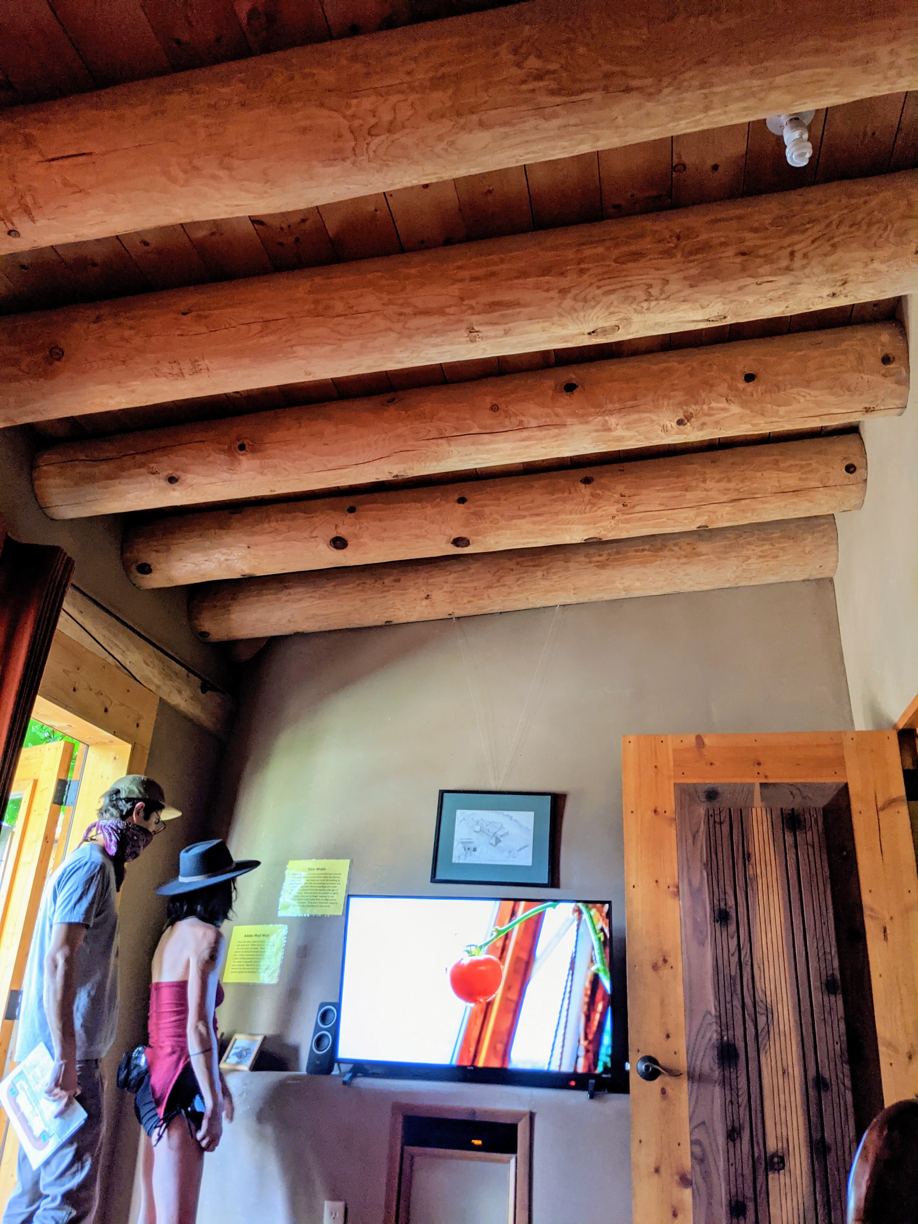
This interior room has amazing wood beams.

The house look rather artsy, built from tires, glass, cans. . .

The spider web windows here are quite handsome.

While the bottles and tires in this wall look kind of junky.
If you would like to see more photos go to https://earthshipbiotecture.com/nightly-rentals/#truchas

Back at our campsite for this bright sunset against storm clouds on the horizon.
June 5, 2021
It is a rest day before we head out tomorrow.

We read outside until the clouds rolled over us and rained down.
You can see the horizon and blue sky over the mountains while it rains on us.

I was captivated by the altar decoration at Sacred Heart Church in Alamosa and thought I would share it with you.
We were quite anxious to read your blog see your pictures from Great Sand Dunes National Park because it is not that far from Kristin’s house and we have thought of driving there for a couple of days. Are dune sizes similar to Sleepy Bear in Michigan? Was it hard climbing the dunes or was it easier because they were wet from the rain? It looked like the slide down was quite fast.
ReplyDeleteHow fun that you met up with your sister and brother in law.
The Dunes (750 ft) are the largest in the US, much larger than the ones at Sleeping Bear Dunes in Michigan(460 ft) and the dune field is massive. In the morning the sands were wet and we did not sink very much so it was easy to walk. In the afternoon the sand was drier, there were more footprints and especially going up hill we sank in the sand a lot which made it troublesome to go up. The slide down is very fast, you need a good incline to get going and that incline makes for a fast run. If you go do hike Zapata Falls walking in the creek is adventurous fun. Yes, meeting up with my sister and brother-in-law was very fun, it was great to see family while out on the road.
ReplyDelete